|
|
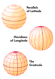
Latitude and longitude form a
geographical coordinate system used for locating places on the surface
of the earth. They are angular measurements, expressed as degrees of a
circle measured from the center of the earth. The earth spins on its
axis, which intersects the surface at the north and south poles. The
poles are the natural starting place for the graticule, a spherical
grid of latitude and longitude lines.
|
|
|
LATITUDE
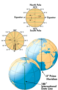
Halfway between the poles lies the equator. Latitude is the angular
measurement of a place expressed in degrees north or south of the
equator. Latitude runs from 0° at the equator to 90°N or 90°S at the
poles. Lines of latitude run in an east-west direction. They are
called parallels because they are equally distant from,
LONGITUDE
Lines of longitude, called meridians, run in a north-south direction
from pole to pole. Longitude is the angular measurement of a place
east or west of the prime meridian. This meridian is also known as the
Greenwich Meridian, because it runs through the original site of the
Royal Observatory, which was located at Greenwich, just outside
London, England. Longitude runs from 0° at the prime meridian to 180°
east or west, halfway around the globe. The International Date Line
follows the 180° meridian, making a few jogs to avoid cutting through
land areas.
|
|
|
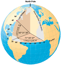
DEGREES, MINUTES, SECONDS
A degree (°) of latitude or longitude can be subdivided into 60 parts
called minutes ('). Each minute can be further subdivided into 60
seconds ("). One degree of latitude equals approximately 69 miles (111
km). One minute is just over a mile, and one second is around 100 feet
(a pretty precise location on a globe with a circumference of 25,000
miles). Because meridians converge at the poles, the length of a
degree of longitude varies, from 69 miles at the equator to 0 at the
poles (longitude becomes a point at the poles). The diagram at right
is an example of a place located to the nearest second. It is written
as: 42°21'30"N 71°03'37"W. This place is city center, Boston,
Massachusetts.
|
|
|
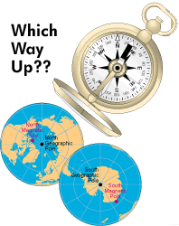
Which way up . . .
The north and south poles are the earth's geographic poles, located at
each end of its axis of rotation. All meridians meet at these poles.
The compass needle points to either of the earth's two magnetic poles.
The north magnetic pole is located in the Queen Elizabeth Islands
group, in the Canadian Northwest Territories. The south magnetic pole
lies near the edge of the continent of Antarctica, off the Adélie
Coast. The magnetic poles are constantly moving. |
|
|